Postcode : TF6, Telford And Wrekin, Shropshire
Postcodes in the TF6 sector. Covering areas such as Rushmoor, Waterside, Rowton, Heath Lanes, Cross Green, Charlton, Allscott, Ellerdine, Poynton, Eyton upon the Weald Moors, Meeson Heath, Ellerdine Heath, High Ercall, Bolas Heath and Telford and Wrekin in Shropshire.
Postcode Area TF : Telford
TF6 Postcode Sectors
TF6 Nearby Postcode Districts
ST20 SY1 SY2 SY3 SY4 SY5 TF1 TF10 TF11 TF2 TF3 TF4 TF5 TF6 TF7
Stations near to TF6
Wellington (Shropshire) Rail Station about 2.79 miles away.TF6 Schools
St Peter's Church of England Controlled Primary School, Bratton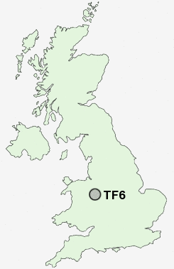
UK Search
Antique Furniture
1000s of pieces of Antique Furniture for sale from British antique dealers.