How To Create Your Own POIs With POIEditor.com
By D Dunbar in Software. October 21, 2006
A POI, in the GPS world, stands for 'Point Of Interest', they are used with GPS navigation devices such as the popular TomTom and others. The idea is that you load your GPS device with various POI files and, as you drive around, your little sat nav machine will alert you to points close by.
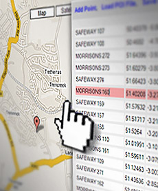
POI Editor
It's great for warning of approaching speed cameras for instance and there are hundreds of POI files available that will do just that, but there are many other POIs around too. These range from petrol stations to National Trust castles and everything in between. Of course there's nothing stopping you from creating your own, either with the GPS device (if it lets you) or with various pieces of software.
POI Editor, as the name suggests, lets you edit POI files, it'll also create them from scratch and, importantly, let you view the actual locations on a very nice map (via the Google Maps API). It can convert between different formats too and happily read TomTom’s binary format (OV2, including zipped OV2) and export to ASCII, CSV (as used by Navman / Garmin), OV2 or KML (Google Earth).
Creating a POI
It's a good idea to know the latitude and longitude for the places you intend to use in your POI. In fact without this basic information it's impossible to build a POI. There are ways to obtain these coordinates, often referred to as Geocoding, and sites such as streetmap.com will give coordinates for postcodes or streets but obtaining them is often a long and tedious process. One alternative is to physically go to the location you intend to have as a POI and use the GPS device to store the coordinates. You can use both these methods with POIEditor, or, you can use the built in map to locate points and their coordinates will be displayed for you.Creating a POI with POI Editor is fairly straight forward so lets get stuck in and create our own.
First, open a new web-browser window, go to www.poieditor.com and click 'Add Point'. A menu should appear that allows us to enter a name and its lat/long position. If you know the lat/long just enter it here along with a name for the location and click the 'Save Point' button. You can enter them in either decimal (e.g. 53.44941, -2.76163) or DMS (e.g. N 53° 26 57, W 2° 45 41) formats, using the WGS84 datum.
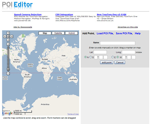
The 'Add Point' screen
Alternatively, clicking anywhere on the map will create a marker with its latitude and longitude automatically shown. The map is probably showing a world view but by using the buttons on the map we can pan and zoom to narrow the view down easily - this should be familiar to anyone that's used Google Maps before. Again, clicking anywhere on the zoomed map will produce a marker that we can drag around to pin-point the location we're looking for. As we drag the marker you can see the lat/long coordinates change in the boxes to the right.
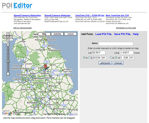
Narrowing the view down
It doesn't take long to locate the UK and then Leeds, where I live, and with a few zooms later I think I've found the location of my local pub. I'll move my marker here (by clicking on the map) and the lat and long positions update in the boxes to the right. Now I need to name my point, I'll pick 'The Pub' and click 'Add Point' to save this as one of my POIs
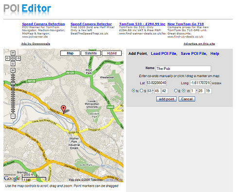
Creating a marker on the map
But before I save, I'm not 100% sure that my marker is in the exact spot. If I click 'Satellite' on the map I get an aerial photo view which lets me zoom to 50ft. I can now see the pub and that marker was a little out, not enough to make much difference when driving by, but I'll move it to right on the pub doors anyway. Clicking the 'Save Point' button, removes the 'add point'box and displays my entry in a list. There's only one so far so lets add some more.
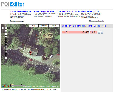
Refining the position with 'satellite view'
I'll now use the same method to add another pub. clicking 'Add Point', zooming out a little, positioning the marker and clicking 'Save Point'. I now have two points in my list and selecting either one will move the map to its location and allows me to drag the marker to further refine the position or change it completely. Clicking the '-' button lets me delete a point from the list if I'm not happy with it.
A few minutes later and I've created a little list of local pubs. Clicking 'Save POI File' brings up a dialog box that lets me enter a name for my POI and select the format. There are a few supported POI formats, I'm selecting TomTom OV2 as that's what my Sat Nav is. It's now just a question of copying the OV2 file to my TomTom and I'm all set with all the local pubs.
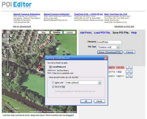
Saving the finished POI
If at a later date I wanted to add more pubs to my POI I could use the 'Load POI' option and then add more points as needed. If I had two separate POI files I could select the merge option within the 'Load POI' page to combine them into one file.
POI Edtior is a really useful website and it's probably the easiest way to build up your own custom POI. Okay, so local pubs may not be the best example of a POI as I'm not likely to need these locations while on a journey or ever forget where the pubs are! But its a good demo of how easy it is to create POIs. POI Editor is great for quickly passing a location to a sat nav owning friend ( instead of giving long winded directions to a meeting place for instance) or even for converting a POI you've downloaded from one format to another.
The main advantages of POI Editor over other software that's available are :
1. POI Edtior is free, 2. There are no downloads or any software to install, 3. It's a website and so available on line where ever you are; home, holiday, visiting a friend, at work etc.etc. and... 4. The integrated map, especially the satellite view which lets you visually pin-point POI locations down to metres/feet.
A disadvantage is that it does slow down with large lists (4000 points or more when using Firefox) .Otherwise this is a great website that I'll be recommending to friends and using often!
Related Articles : TomTom ONE New Edition, The New TomTom ONE, The New Mio H610, Mitac Mio P350 And P550
Software
 AA Route Planner 2008
A very basic, cheap and cheerful routeplanner from the AA
 Autoroute 2007
Latest incarnation of Microsoft's popular Autoroute software
 Memory-Map Review
3D Views, OS Maps, GPS support: lose yourself in this mapping software.
UK Search
 AA Autoroute
The AA's latest Route planning software.
GPS
 Garmin Nuvifone Screenshots
The nuivfone will be Garmins first entrance into mobile phone market.
 Binatone X350 GPS Review
The Binatone X350 is one of the cheapest entry level Sat Navs around.
 TomTom GO 940 Live
TomTom are back with a new top end TomTom GO
 Packard Bell Compasseo
This month sees the introduction of two new GPS devices from Packard Bell.
 New Mio C510E
The latest from Mitac is the new Mio C510E
 1 Second Fix With New GPS Chip
New GPS chip, the u-blox 5, boasts Galileo compatibility and a 1 second TTFF
 TomTom 910s hit with virus
TomTom has confirmed 910s shipped with viruses
 Garmin ETrex GPS Navigator
The Etrex is a cheap GPSr ideal for outdoor use.
 Amaryllo Purity Bluetooth receiver
A bluetooth GPS system using the new SiRFstar III LP chipset
 Medion GoPal 210
At £99 the GoPal 210 must be the cheapest SiRF Star III sat nav around?
 Navman F20
The F20 is a simple, easy to use GPS.
 Garmin Street Pilot C550
The StreetPilot C550 is Garmin's answer to TomTom's top of the range 910 model
 Mitac Mio C250 DigiWalker
Mio's budget GPS unit at around £170 but packing some really nice features.
 Garmin Forerunner 101
The Forerunner 101 offers walkers and runners an entry-level GPS trainer device.
 Nokia 330 Auto Navigation
The 330 Auto Navigation is Nokia's first entry into dedicated satellite navigation.
 Sony nav-u NV-U51 and NV-U71T
Sony attempts to crack the TomTom market with its new NV-U51
 Garmin Nuvi 300
The nuvi 300 is a GPS navigator and digital entertainment system, all in one.
 TomTom ONE New Edition
A year on from the original ONE, this new release sees some significant changes
 The New Mio H610
The new Mitac Mio H610, due end of October
 Mitac Mio P350 And P550
Brief overview of the Mio P350 and P550
 Garmin Streetpilot i3
Despite its size the i3 will perform many of the functions of a normal sized device.
 TomTom One
TomTom's One based on the TomTom GO 300 but with a few extras...


