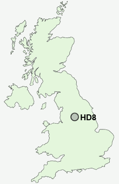
Postcode : HD8, Kirklees, West Yorkshire
Postcodes in the HD8 sector. Covering areas such as Kitchenroyd, Nether End, Shelley, Dogley Lane, Houses Hill, Birds Edge, Thorncliff, Highburton, High Green, Denby Dale, Lane Head, Causeway Foot, Clayton West, Park Gate and Kirklees in West Yorkshire, South Yorkshire.
Postcode Area HD : Huddersfield
HD8 Postcode Sectors
HD8 8 Birds Edge, Denby Dale, High Flatts, Ingbirchworth, Kitchenroyd
HD8 0 Causeway Foot, Dogley Lane, Fenay Bridge, Gawthorpe, High Green
HD8 0 Causeway Foot, Dogley Lane, Fenay Bridge, Gawthorpe, High Green
HD8 Nearby Postcode Districts
HD1 HD2 HD3 HD4 HD5 HD7 HD8 HD9 HX4 HX5 HX6 OL3 OL4 OL5 S36 S63 S70 S71 S72 S73 S74 S75 WF1 WF12 WF13 WF14 WF2 WF4 WF5 WF6 WF7 WF8 WF9
Stations near to HD8
Shepley Rail Station about 1.36 miles away.Stocksmoor Rail Station about 1.88 miles away.
Denby Dale Rail Station about 2.06 miles away.
HD8 Schools
Shelley College, A Specialist Centre For ScienceShelley First School
Kirkburton Church of England Voluntary Aided First School
Kirkburton Middle School
Skelmanthorpe First and Nursery School
St Aidan's Church of England Voluntary Aided First School
Shepley First School
Cumberworth Church of England Voluntary Aided First School
UK Search
Antique Jewellery
including Antique Engagement Rings for sale from UK Antique specialists.
