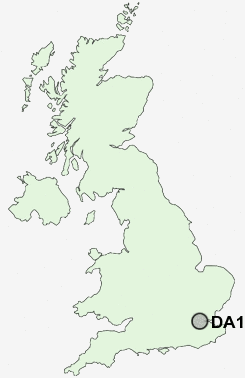
Postcode : DA1, Kent, London
Postcodes in the DA1 sector. Covering areas such as Northfleet Green, Shorne Ridgeway, Blackfen, Great Buckland, Crayford, Priestwood Green, Cobham, Welling, Istead Rise, Hook Green, Belvedere, Bowmans, Chalk, Singlewell, Southfleet, Kent and Greater London in Bexley, Greater London, Bromley, Greater London.
Postcode Area DA : Dartford
DA1 Postcode Sectors
DA1 Nearby Postcode Districts
BR1 BR2 BR3 BR4 BR5 BR6 BR7 BR8 CR0 CR2 CR4 CR7 DA1 DA10 DA11 DA12 DA13 DA14 DA15 DA16 DA17 DA18 DA2 DA3 DA4 DA5 DA6 DA7 DA8 DA9 E1 E13 E14 E15 E16 E1W E2 E3 E6 E7 E8 E9 EC1 EC1A EC1M EC1N EC1R EC1V EC1Y EC2 EC2A EC2M EC2N EC2R EC2V EC2Y EC3 EC3A EC3M EC3N EC3P EC3R EC3V EC4 EC4A EC4M EC4N EC4R EC4V EC4Y IG11 ME1 ME2 ME3 ME4 ME5 ME7 ME8 N1 NW1 NW8 RM10 RM13 RM15 RM16 RM17 RM18 RM19 RM20 RM9 SE1 SE10 SE11 SE12 SE13 SE14 SE15 SE16 SE17 SE18 SE19 SE2 SE20 SE21 SE22 SE23 SE24 SE25 SE26 SE27 SE28 SE3 SE4 SE5 SE6 SE7 SE8 SE9 SM5 SM6 SS17 SS8 SW1 SW10 SW11 SW12 SW16 SW17 SW18 SW1A SW1E SW1H SW1P SW1V SW1W SW1X SW1Y SW2 SW3 SW4 SW5 SW7 SW8 SW9 W1 W1B W1C W1D W1F W1G W1H W1J W1K W1M W1S W1T W1U W1W W2 WC1 WC1A WC1B WC1E WC1H WC1N WC1R WC1V WC1X WC2 WC2A WC2B WC2E WC2H WC2N WC2R
Stations near to DA1
Dartford Rail Station about 0.4 miles away.Crayford Rail Station about 1.34 miles away.
Slade Green Rail Station about 1.66 miles away.
Purfleet Rail Station about 2.62 miles away.
Erith Rail Station about 2.83 miles away.
Farningham Road Rail Station about 3.32 miles away.
DA1 Schools
West Hill Primary SchoolDartford Science & Technology College
Temple Hill Community Primary and Nursery School
The Leigh Academy
Wilmington Enterprise College
The Brent Primary School
Fleetdown Infant School
Fleetdown Junior School
UK Search
Antique Jewellery
including Antique Engagement Rings for sale from UK Antique specialists.