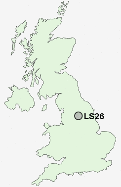
Postcode : LS26, Leeds, West Yorkshire
Postcodes in the LS26 sector. Covering areas such as Methley, Wood Row, Hungate, Great Preston, Lower Mickletown, Hollinthorpe, Mickletown, Royds Green, John O'Gaunts, Methley Junction, Carlton, Swillington, Methley Lanes, Oulton and Leeds in West Yorkshire.
Postcode Area LS : Leeds
LS26 Postcode Sectors
LS26 0 Carlton, Rothwell, Rothwell Haigh
LS26 8 Great Preston, Hollinthorpe, John O'Gaunts, Little Preston, Oulton
LS26 8 Great Preston, Hollinthorpe, John O'Gaunts, Little Preston, Oulton
LS26 Nearby Postcode Districts
BD1 BD10 BD11 BD12 BD14 BD15 BD16 BD17 BD18 BD19 BD2 BD3 BD4 BD5 BD6 BD7 BD8 BD9 HD2 HD3 HD6 HX3 HX5 LS1 LS10 LS11 LS12 LS13 LS14 LS15 LS16 LS18 LS2 LS25 LS26 LS27 LS28 LS3 LS4 LS5 LS6 LS7 LS8 LS9 WF1 WF10 WF11 WF12 WF13 WF14 WF15 WF16 WF17 WF2 WF3 WF5 WF6 WF7 WF8 YO8
Stations near to LS26
Woodlesford Rail Station about 0.39 miles away.LS26 Schools
Oulton Primary SchoolWoodlesford Primary School
Rothwell St Mary's RC Primary School
Royds School
Rothwell Church of England Voluntary Controlled Primary School
Rothwell Primary School
Rothwell Haigh Road Infant School
Victoria Junior School
Swillington Primary School
UK Search
Antique Jewellery
including Antique Engagement Rings for sale from UK Antique specialists.